

Posted by Guest: Josh Adams on 8/8/2019 to
Client Success Stories

Josh Adams is the Missouri Trails Project Coordinator for Missouri Park & Recreation Association. He was kind enough to share their experiences using the Eos Arrow 100 GNSS receiver with Esri's Collector app for mapping trails in Missouri, both by foot and by bike.
The Missouri Trails Project
Missouri is the home of thousands of miles of trails, ready for every kind of user to experience and enjoy. In January 2018, I started working on Missouri Trails Project (MTP) as Project Coordinator. Our mission is to map out all the trails in Missouri, including designated activities such as walking, biking, equestrian, motorized, and accessibility. A software development company managed earlier versions of the project with a product that was cost prohibitive and buggy. My first task was to access the current website and data and explore other options. It was not long before MTP made the switch to an ESRI ArcGIS Online platform. For display of the progress, we embedded our map into a Wix domain for hosting information provided to trail users and trail managers, www.visitmissouritrails.com. Within one year of the project, the database has grown from around 600 GIS miles to over 6,200 GIS miles of trail data with more added each week. About 80% of the project database was built using shared GIS data from many trail managing agencies in Missouri and appending to the current table to create uniformity.

Equipment and Workflow
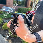
To keep things simple, from several recommendations, the MTP purchased an EOS Arrow 100 with accessories from the helpful staff at Anatum GeoMobile Solutions. My preferred setup is the baseball cap with pocket for antenna cabled to the Arrow 100 connected via Bluetooth on our iPad Pro. I’m currently testing using an Android mobile phone in lieu of the iPad making it easier to hike or bike the trails and collect data. Project workflow consists of connecting with Missouri Park & Recreation (MPRA) members and non-members in different communities across the state of Missouri to request their trail data and KMZ or Shape files in ArcGIS Online. After reviewing and formatting, the data is uploaded directly into the database. There are some variances between agencies involved but we do our best to be consistent. If no GIS data is available, I simply collect the trail line using the equipment above and upload from ArcGIS Collector Classic. I am also using ArcGIS Explorer App on my phone to help locate my 250+ mapping sites I have marked out for trail line collection.
Implementation Problems and Solutions
A few issues using the new ArcGIS Collector app occurred when I was streaming my line, it would end after 1,000 feet. ESRI walked me through some solutions but eventually, I just used Collector Classic. The only issue I found with Classic was the base map had to be USA USGS Topographic - any other would not save and error out. I believe this was related to the very long line data that I was collecting but not positive. I found Classic was able to create and stream shape line data over 8 miles continuously in one collection. Another issue was typing all the details for the trail information until I discovered the Domain Value for each field, which is easy to use in creating dropdown values for consistent information. For example, in the activity fields, we simply decided to mark YES or NO for each field making it simple to collect in the field with a tap on the screen.
Final Product for Public Consumption
Utilizing our web map through ArcGIS Online, we are able to host a robust map that the public can use to learn more about each trail across the whole state of Missouri. Users can visit www.visitmissouritrails.com move around the map, zoom in and out, and click on any trail of interest to see information like the trail name, the overall length of the trail, what agency manages it, what activities are allowed, and even surface type when available.
Although the Recreational Trails Program Grant funding will end in December 2020, it has been an honor and very exciting to be a part of this project. I’m hoping the MPRA Trails Summit in the Fall of 2020 will be as successful as this project when we present many possible trail connections. Be Happy, Be Healthy, Be Outside, Happy Trails!

Tagged Products
 This product is currently on back order. We will ship upon restock arrival.
$3,130.00