Posted by Matt on 4/9/2018 to
Adopting Mobile GIS
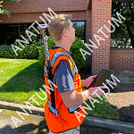
iPad, Arrow Gold RTK, GPS Vest, and Esri Collector for ArcGIS combined for field data collection of 600 assets a day!
I first spoke with David Johnson and Kurt Towler of Sulphur Springs Valley Electric Coop (SSVEC) in late 2016. They had an ambitious plan to move their field data mapping methods and equipment to Mobile GIS with RTK accuracy to accurately map 7,600 facilities and an estimated more than 30,000 assets in 3 months time with two field surveyors. I like a challenge, but even I was impressed when they added that they wanted to hit the ground running in one month's time!
Designing A Solution
Luckily for SSVEC, Kurt is a GIS guru and not afraid to learn new things. He was more than willing to jump feet first into moving their system over to ArcGIS Online and Collector for field data mapping. Even better for ease of deployment, they had already settled on using iPad Mini's for their data collector. In the last five years, Anatum has seen much easier deployment with iOS for RTK work when compared to Android and Windows 10. Plus, Esri has thus far developed app updates to iOS first before later deployment to the other platforms.
The three of us spent some time in a webinar demo where I showed the various GNSS receiver options that would work well with Collector running on an iPad. From there we discussed how the Eos Arrow Gold RTK receiver would be their best option. The reasons for this were the following:
- Eos receivers will work with Android, Windows, and iOS, in case SSEVC decided to change tablet types in the future
- Eos receivers are completely agnostic to data collection software, meaning they play nice with everyone
- Use with RTK network or single base station is easy and user-friendly
- Sulphur Springs has a fairly long baseline to the nearest RTK base station, so the Arrow Gold could maximize accuracy given their geography
- If some areas had spotty cell service, the Arrow Gold could take advantage of subscription satellite corrections of sub-10cm if necessary
- Affordable cost compared to other manufacturers and more reliable compared to some manufacturers RTK receivers
- There is the option to set up their own Arrow Gold RTK base station locally for maximized accuracy
With the decision of field collection software, tablet type, and RTK receiver settled, the last step was to decide on the best method to handle the Arrow Gold RTK receiver antenna in the field. Typically, the workflow for centimeter accuracy would be to mount any RTK receiver on a 2-meter range pole. This allows the user to get the antenna above their head to maximize accuracy, and allow them to use the poles bubble level to ensure that they are holding the pole straight and directly over the spot they are mapping. Since SSVEC was interested in balancing accuracy and ease of field use, and the fact that the surveyors would be walking miles of transmission lines, they decided to go with our custom GPS Vest. This allowed the surveyors to carry their iPad Mini in one hand and have one hand free for the easiest hiking solution.

Field Results
Impressively, SSVEC was up and running in under one month. Even more impressive is how quickly they completed a large mapping job:
| Field Data Collection | |
| Total Locations Inspected | 7,640 |
| Asset Records Collected | 34,000+ |
| Days of Collection | 32 |
| Average Locations Per Day | 235 |
| GPS Quality | |
| Median Accuracy Per Location | 4.6 cm |
| Median Distance from Old Locations to New | 5 feet |
| Minimum Distance | 1.2 inches |
| Maximum Distance | 345 feet |
They collected an average of 235 assets per day! Impressive by any standards.
SSVEC significantly improved the accuracy of its 8,000 facilities, Kurt says the asset reconciliation project has completely changed the way SSVEC understands its asset inventory.
"Many assets moved 50 - 100 feet," Kurt said. "That's a big difference when you look at a road and want to know on which side of the road the pole is located."
Kurt says the productivity, scalability, and reliability of Collector and cloud technology has been proven. Today's GIS, GNSS, and related technologies are far more valuable and far less expensive than ever before.
"We built an entire GIS program with te explicit idea that our decision-makers should have the accurate and reliable information to run a power company." Kurt finishes, "In this project, we proved that we can delivery."
To watch Kurt's full presentation with the Electric and Gas User Group's Birds of a Feather Series, please play the video below. You can also learn more about Kurt's experiences and knowledge in GIS by visiting his Podcast at Speaking of GIS.
And let us know if you would like any GIS, Tablet, GNSS, RTK, or Software consulting!
Tagged Products